The 4 Religion Alliances
- Conservative Sunni’s
- Saudi’s
- United Arab Emirates (Abu Dhabi, Dubai)
- Jordan
- Morocco
- Radical Sunni’s
- Muslim Brotherhood
- Qatar
- Turkey
- Hamas
- Shia
- Iran
- Iraq
- Syria
- Lebanon
- Yemen
- Other
- Israel
- Kurds
- Druze
- Hamas is the only radical overlap between Shia and Sunni
Maps for regional orientation
Historical comparison: The Cauldron — Simon Sebag Montefiore supplies a chronological test of the alliance groupings above. Treat those groupings as a rough study heuristic: the book traces changing state interests, local armed movements, and alliances that cross religious identities. Religious affiliation does not establish a community’s political allegiance. Start with the book note’s period reviews and use the maps below for geography.
Modern reconstructions of historical political geography. Distinguish formal sovereignty, military occupation, protectorate relationships, and direct administration. In 1900 Egypt was British-occupied but remained nominally Ottoman; Britain declared its formal protectorate in 1914. Hatching should not be read as identical government arrangements everywhere. Modern boundary lines are orientation aids. These are Izady’s geographic reconstructions and estimates, not a uniform census series or maps of political allegiance. Dates and classifications belong to each image; religious affiliation does not establish support for a government or armed group.
Who controlled the region around 1900
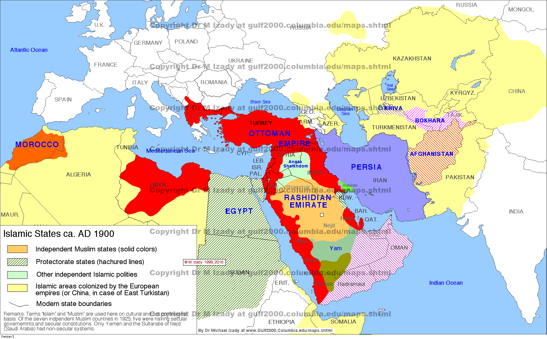
A quick view of independent polities, European colonial territories, and areas shown as protectorates around 1900. Use the detailed companion below to distinguish different imperial relationships.
Map source: Dr. Michael Izady, Gulf/2000, Columbia University. Original map · Collection. Personal reference use; copyright remains with the author.

Political control around 1900: detailed
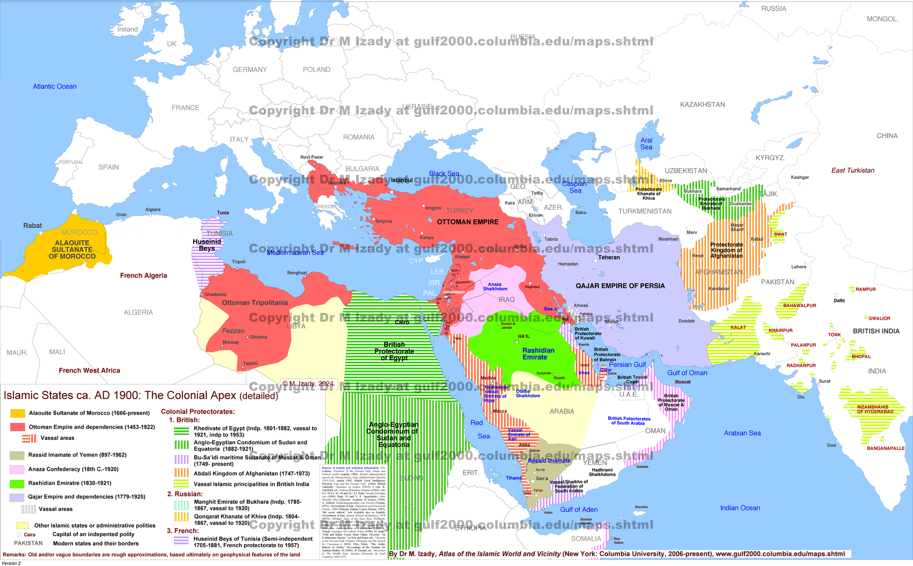
The detailed companion distinguishes imperial territories and several forms of dependency. This is the most useful saved map for the Ottoman-versus-British question.
Map source: Dr. Michael Izady, Gulf/2000, Columbia University. Original map · Collection. Personal reference use; copyright remains with the author.

Ethnic groups across borders
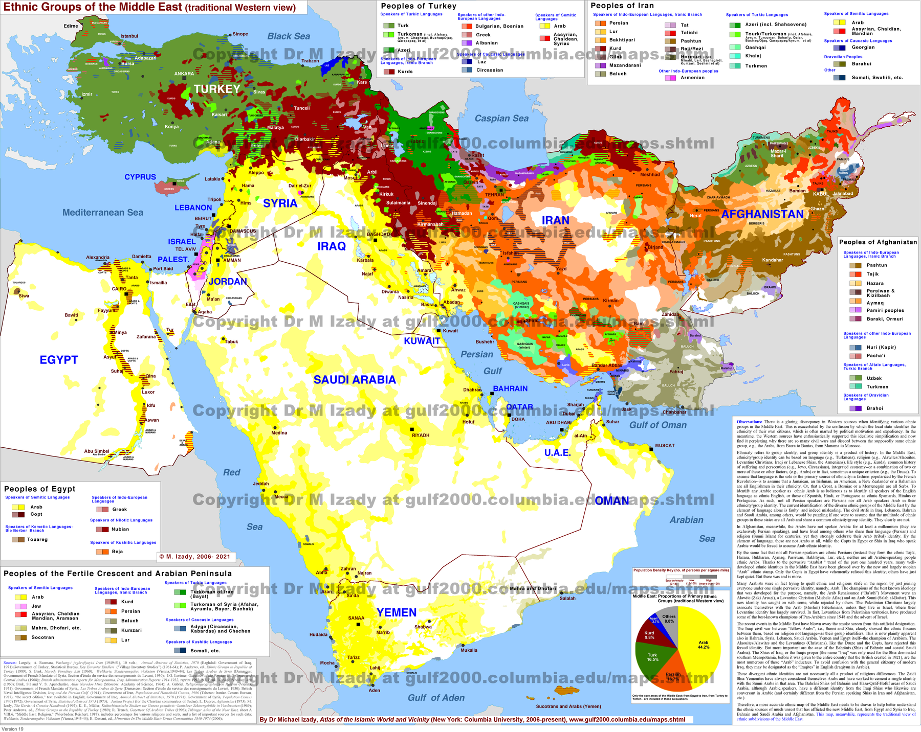
Compare the distribution of named communities across state borders. The map’s categories and percentages are the author’s estimates; large colored areas do not necessarily contain large populations.
Map source: Dr. Michael Izady, Gulf/2000, Columbia University. Original map · Collection. Personal reference use; copyright remains with the author.
Religious geography
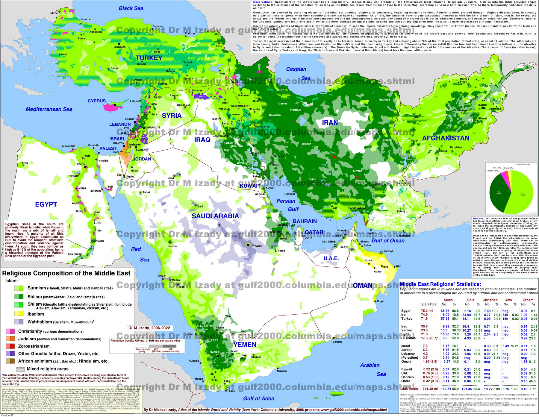
Locate religious communities geographically. The legend uses Izady’s classifications, including some contested groupings; it should not be treated as a theological consensus.
Map source: Dr. Michael Izady, Gulf/2000, Columbia University. Original map · Collection. Personal reference use; copyright remains with the author.

Languages across borders
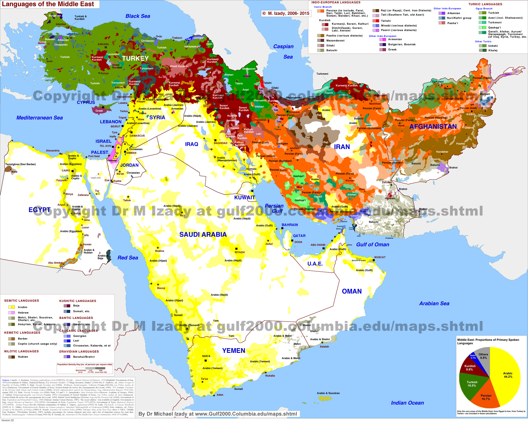
Use alongside the ethnic and religious maps to distinguish language, ethnicity, religion, and nationality. These dimensions overlap without being interchangeable.
Map source: Dr. Michael Izady, Gulf/2000, Columbia University. Original map · Collection. Personal reference use; copyright remains with the author.
Source and interpretation: Gulf2000 map collection.